
Gozo is only a small island, but the landscape along its coast is uniquely diverse and full of natural beauty. A walk around the coast of Gozo is approximately 55 kilometers long, and is typically divided into daily sections of about 10-15 kilometers each. For the more adventurous, the daily sections can be increased. Alternatively, one can take only a short section of the walk to explore a more limited area.
The terrain is a combination of country roads, foot paths, town pavements and several sections without a well-defined path. Some stretches of the coastal route are more challenging hikes, whereas others are easy walks. Overall, Gozo coastal walk is a moderate difficulty hike around the beautiful coast of Gozo. The island has uneven terrain, so going up and down hills and inclines is to be expected.
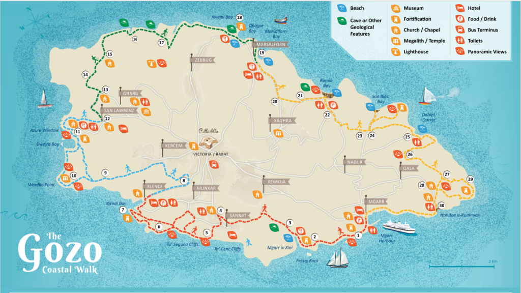
The Gozo Coastal Walk, developed by the ministry for Gozo, has a brochure which can be downloaded from the Visit Gozo website. While some sections of the walk, designed in 2016, may need to be modified – for example, the Azure Window collapsed in 2017 – the principal route remains unchanged. One needs to make sure to take precautions for the weather, as the rain can make some sections of the walk slippery. It is also important to take care not to walk on private property, which is typically duly marked as such.
The easiest section of the walk goes from San Lawrenz to Marsalforn (the green path marked on the map). It is possible to start it from Dwejra (point 11 on the map) and enjoy the picturesque coast. From San Lawrenz, which is connected by bus to Victoria, the walk goes north and takes you to San Dimitri Chapel in Gharb.
This chapel is dedicated to a Byzantine saint, Demetrius of Thessaloniki. Saint Demetrius is not well known in modern Catholicism, and the presence of this chapel points to Malta’s Byzantine past. According to the local legend, Saint Demetrius saved a local woman’s son from North African pirates by literally jumping out of the painting of himself, together with his horse. He rescued the boy and jumped back into the picture.
The path passes along scenic valleys of Wied il-Mielah and Wied l-Ghasri, leading to the ancient salt pans which have been in use since the Roman times. While mostly a tourist attraction by now, they are still in use. The walk follows to the beautiful Xwejni bay with its unusual limestone formations. The walk ends in the seaside resort of Marsalforn, which has frequent bus connections to Victoria, as well as many bars, cafes and restaurants to rest in.
Another beautiful area to explore is the coast of the village of Qala, starting from the tranquil Dahlet Qorrot bay, and walking on the rocky coast along the easternmost tip of the island down to Hondoq bay with its incredible views of Malta, Comino and the Blue Lagoon. In season, there are small boats going from Hondoq to Comino and back every hour. From Hondoq, one can continue along the coast further down to Mgarr Harbour, where the ferries from Malta and Comino berth.
The best time for taking coastal hikes is in the shoulder season, October to December and March to May. In the summer, the Maltese sun is too strong for long hikes. In January and February, it is typically cold and rainy. These are also the months when Malta and Gozo often get extremely windy (although strong winds can happen any time of the year). Additionally, it is best to avoid rocky paths in the rain, as some of the limestone gets dangerously slippery when wet.